Weather Map Symbols Chart Manufacturer,Supplier and Exporter in India
Product Code : EL-GC-10126
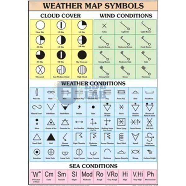
Quick Answer: The Weather Map Symbols Chart is a 70 x 100 cm geography wall chart that sets out the symbols used for different types of clouds, for weather and wind conditions and for sea conditions, with English and Hindi on the same sheet.
Last updated: October 2026
Key Features
Symbols for various types of clouds.
Symbols for weather and wind conditions, and for sea conditions.
Printed in multicolour, in natural colours, on 80 gsm map litho paper.
Hot-seal polyester film laminated on both faces.
Plastic rollers fitted at top and bottom for hanging.
English and Hindi text combined.
Technical Specifications
Specification
Value
Size
70 x 100 cm
Paper
Map litho paper, 80 gsm
Printing
Multicolour, in natural colours
Lamination
Hot-seal polyester film, both sides
Rollers
Plastic, at top and bottom
Language
English and Hindi combined
About This Product
Reading a weather map starts with knowing its symbols, and this chart gathers the cloud, wind, weather and sea-condition symbols in one place for the geography room. Students can check a symbol against the chart while they interpret a map, and the bilingual text lets them read it in English or Hindi. Educational Lab Equipments can supply and export the Weather Map Symbols Chart to Belize, Chile, South Africa, Laos, Malawi and Equatorial Guinea.
Frequently Asked Questions
What symbols does the Weather Map Symbols Chart cover?
It shows the symbols for various types of clouds, for weather and wind conditions, and for sea conditions.
What size is the chart and how is it hung?
It measures 70 x 100 cm and is fitted with plastic rollers at the top and bottom for hanging.